
A site plan is a scaled drawing of a property that shows existing conditions and everything proposed on it: buildings, driveways, parking, walkways, grading, drainage, utilities, landscaping, and setbacks. Cities and counties require one for most building and development permits, because it's how the reviewer confirms the project fits the property and meets local code.
That's the one-paragraph answer. The rest of this guide shows what a site plan looks like (with examples from real stamped plan sets), what goes on one, who draws it, what it costs, and how the permit review process runs. It's written for developers, builders, and property owners, not engineers.
What does a site plan include?
A complete site plan answers three questions for the plan reviewer: what's on the property today, what are you proposing, and does the proposal comply with the rules that apply to this parcel. To do that, most site plans include:
- Property boundaries and legal description. Lot lines with bearings and distances, taken from a boundary survey.
- Existing conditions. Current structures, pavement, trees, easements, wells, septic systems, and topography.
- Proposed buildings and structures. Footprints with dimensions and distances to lot lines.
- Setbacks. The required front, side, and rear setback lines, with the proposal shown inside them.
- Access and circulation. Driveways, drive aisles, parking stalls, loading areas, sidewalks, and how they connect to the public street.
- Grading and drainage. Existing and proposed contours or spot elevations, and where stormwater goes. On larger projects this becomes its own sheet: see what a grading plan is.
- Utilities. Water, sanitary sewer, storm sewer, and where they connect to public systems.
- Stormwater management. Ponds, basins, infiltration areas, or other treatment where required.
- Landscaping and screening where the jurisdiction requires it.
- Title block and scale. Project name, preparer, date, north arrow, and a graphic scale bar.
Not every project needs every item. A detached garage needs a fraction of this list. A commercial building needs all of it, usually spread across multiple sheets of a civil plan set.
Site plan examples from real projects
Most articles on this topic show generic clip art. These are eight real sheets from Land Pro Civil plan sets, the kind of drawings that go to a city or county for review. A full site plan set usually includes several of these.
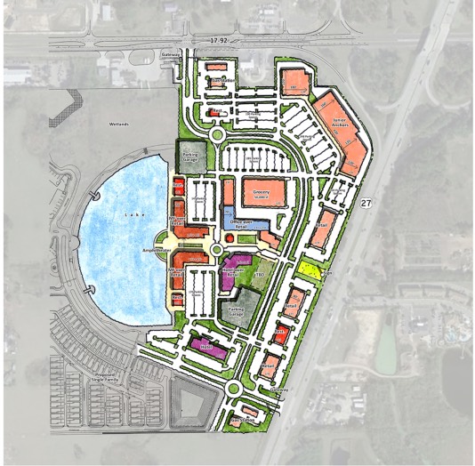
Building pads, parking, internal streets, and a large stormwater pond, drawn in color for entitlement meetings. This is the "does the program fit the land" sheet that comes before detailed engineering.
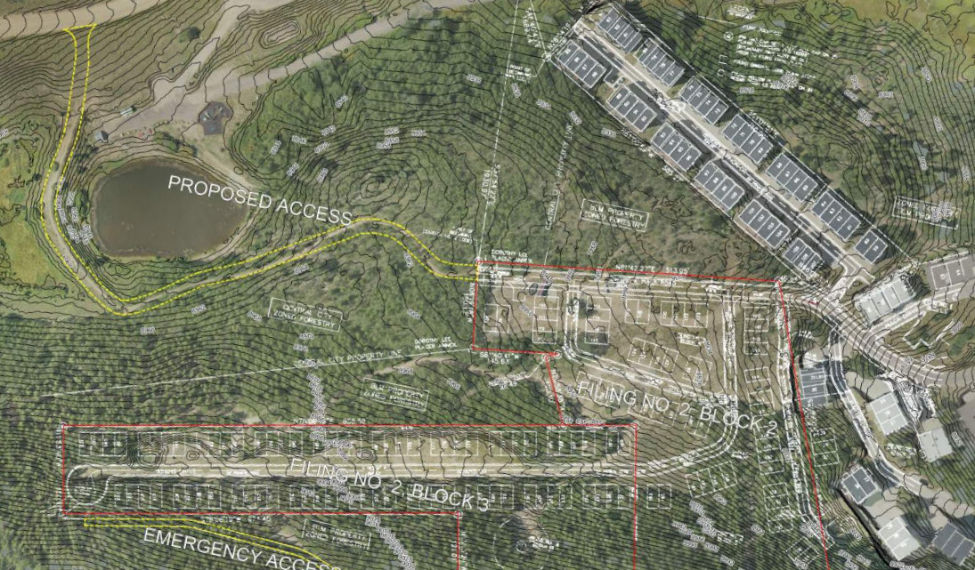
Proposed access, emergency access, and building blocks drawn over an aerial photo, so the owner, county, and fire department can judge the layout against the real terrain. See the project →
Alley-loaded townhomes on a small infill lot: building footprints, the alley, and how the site ties into the street, all inside tight city setbacks. See the project →
Road alignment through steep, rocky terrain. Checking the county road standards let us narrow these roads, which cut grading and paving costs for the developer. See the project →
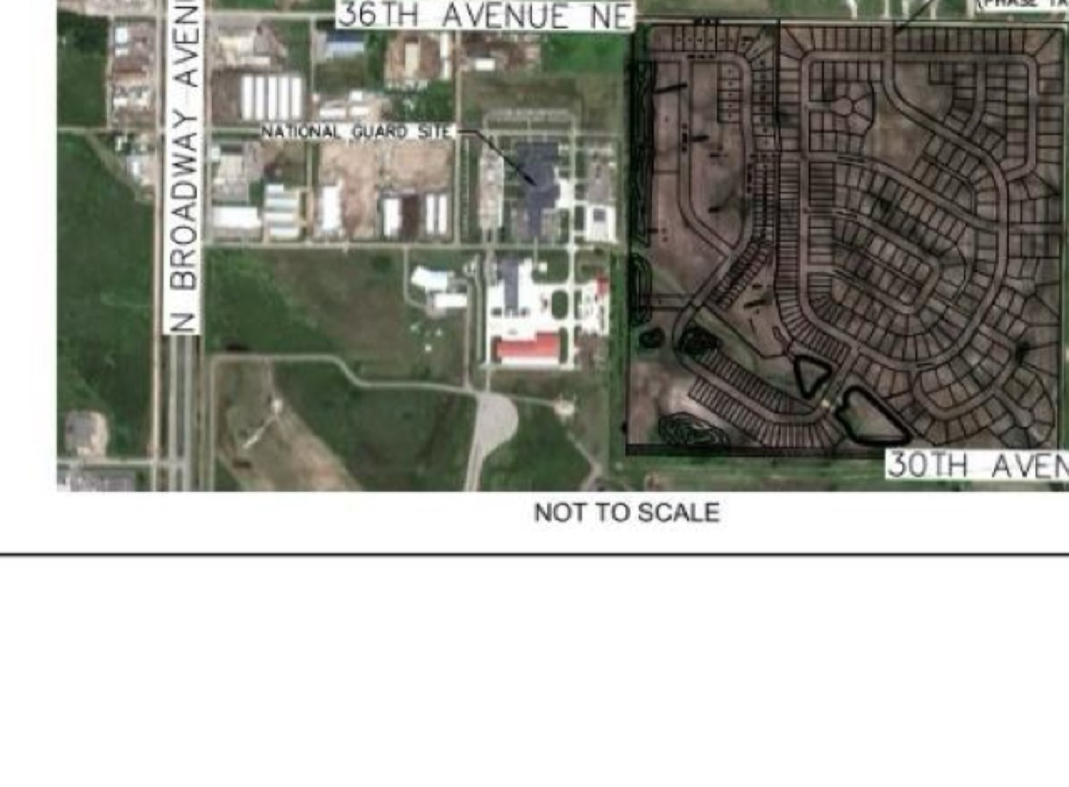
Where the site sits against the surrounding streets. Almost every plan set opens with one, usually marked not to scale, so reviewers know exactly where they are. See the project →
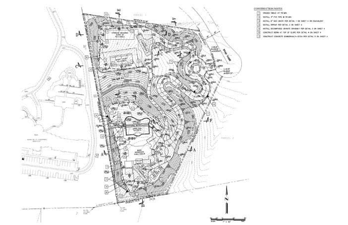
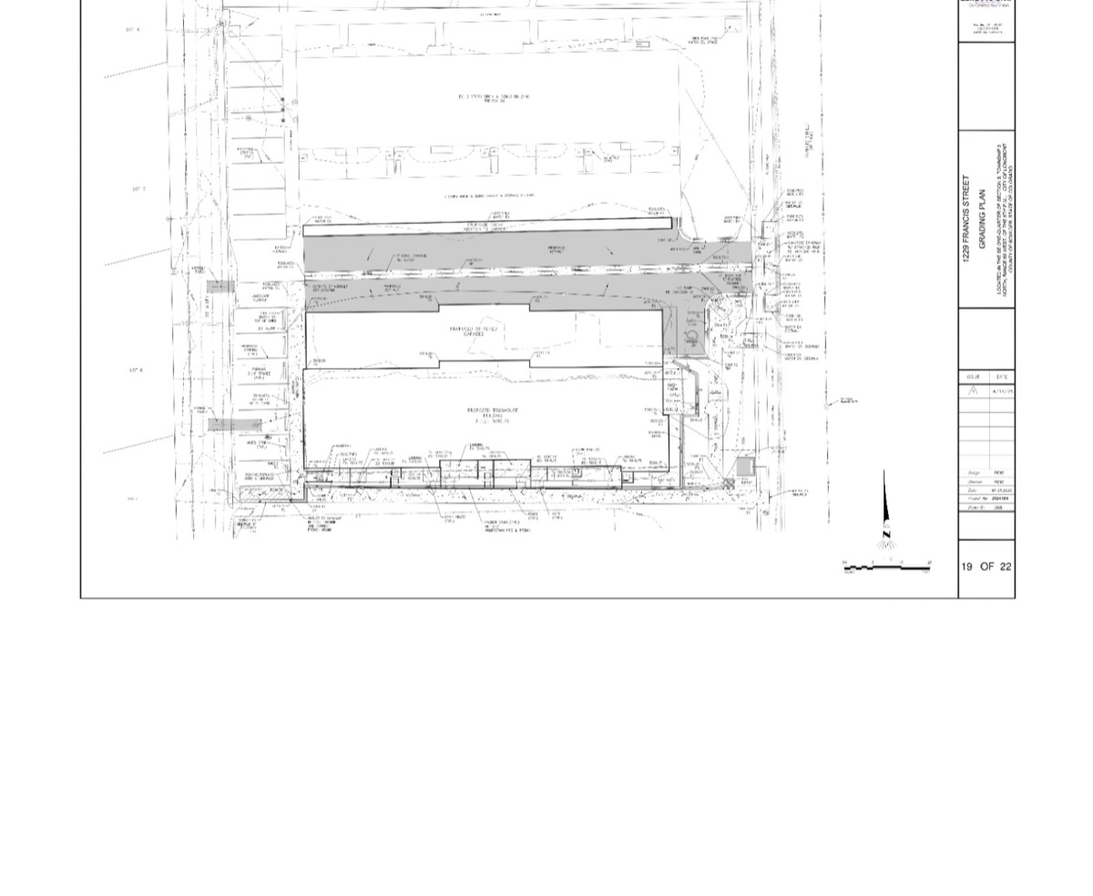
Contours, spot elevations, and drainage arrows that show how the finished ground sheds water. It is often its own sheet in the set. Read the guide →
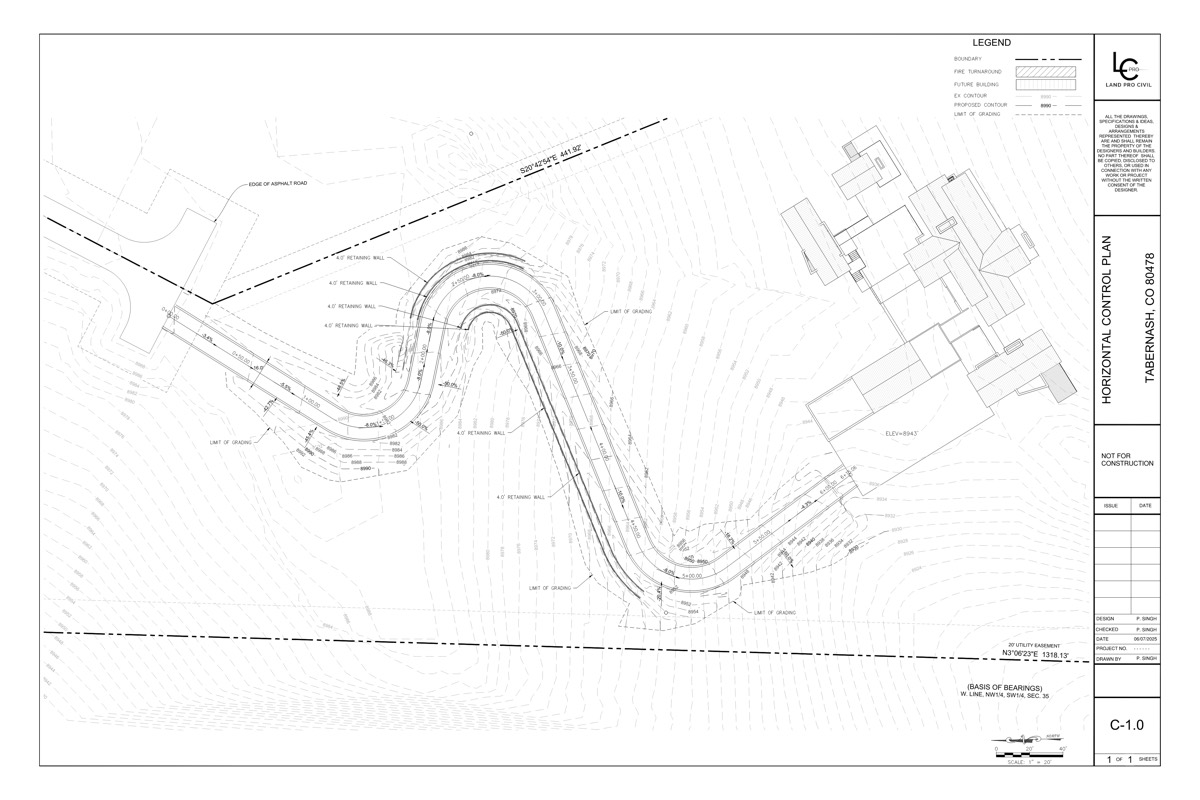
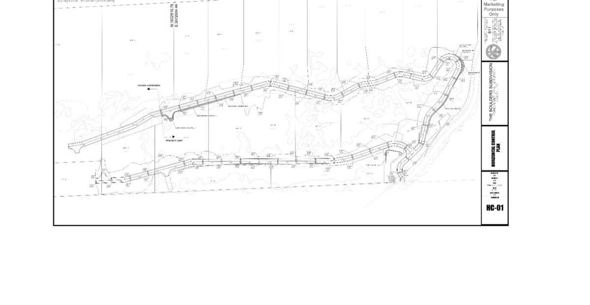
Every curve and line tied to coordinates so the contractor can stake it in the field. This driveway stays inside Grand County and fire department slope limits. See the project →
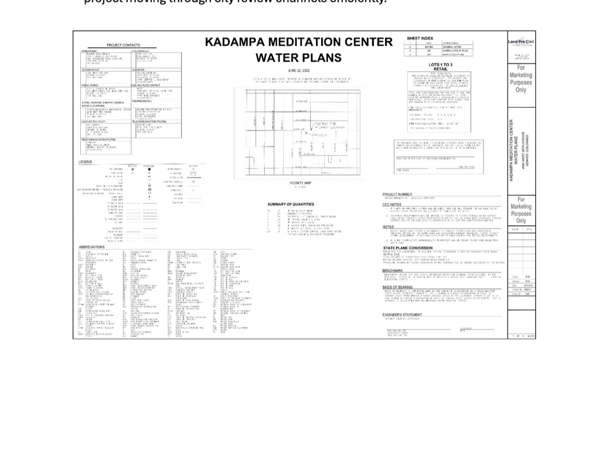
Domestic and irrigation water services, meters, and backflow prevention, laid out to Denver Water standards on a tight urban lot. See the project →
Look across these and the permit-ready sheets share the same basics: a defined boundary, a north arrow, a scale, dimensioned improvements, and drainage you can see on the sheet. That last one is what separates a site plan from a sketch. Reviewers read the drainage first, because water is what causes neighbor complaints and code problems after construction.
Site plan vs. plot plan vs. architectural site plan
Three overlapping terms that trip people up:
- Plot plan. The simplest version: one lot, property lines, building footprint, setbacks. Often hand-drawable for a small residential permit. Some cities say "plot plan" and mean exactly this; others use it interchangeably with site plan.
- Site plan. The full picture described above: existing conditions plus everything proposed, including grading, drainage, utilities, and access. On development projects this is a civil engineering deliverable.
- Architectural site plan. The architect's version, focused on the building: orientation, entries, hardscape design, and how the building relates to the site. It complements the civil site plan rather than replacing it. The architect handles the building; the civil engineer handles the land. On permit submittals, cities typically want the civil version for grading, drainage, and utilities, whatever the architect has drawn.
If a city checklist asks for a "site plan" and your project involves any earthwork, drainage change, or new utility connection, assume it means the civil version. Showing up with only an architectural site plan is one of the most common causes of a rejected first submittal.
How to make a site plan
The real answer depends on the project size. Here's the actual process for each tier.
Small residential project (shed, deck, fence, small addition)
Many cities accept a simple drawing you make yourself. The workable method:
- Start from your property survey (often in your closing documents) or your county's GIS parcel map.
- Draw the lot to scale, label the property lines with their lengths, and add a north arrow.
- Draw existing structures and the proposed work with dimensions, including distance to each lot line.
- Check the measured setbacks against your zoning district's requirements before you submit, not after.
A GIS parcel map is not a survey, and cities know it. If the project is anywhere near a setback line, get the boundary staked by a surveyor. Guessing at a lot line to save a few hundred dollars is how projects end up in variance hearings.
New house, garage with grading, or driveway work
This tier usually needs a surveyor and often a civil engineer. The survey establishes the boundary and topography; the engineer designs the grading and drainage so the lot drains correctly and the city's drainage review passes. In 2026, a residential site plan package for a permit typically costs $1,000 to $4,000. The full breakdown is in our civil engineering cost guide.
Commercial, multifamily, or subdivision projects
This is a civil engineering scope from the start. The typical sequence:
- Boundary and topographic survey. A licensed surveyor maps the property, its topography, and existing features.
- Concept layout. The engineer (often with the architect) tests whether the program fits: building, parking counts, access, stormwater footprint, setbacks.
- Due diligence. Zoning check, utility availability, wetland screening, soils, and which agencies will review the project.
- Design development. The site plan matures into a full civil set: site, grading, drainage, utility, and erosion control sheets, plus a stormwater report.
- Agency submittal and review. City planning and engineering review, plus watershed district, county, or state DOT review where they have jurisdiction.
- Revisions and approval. Respond to review comments, revise, resubmit. Approved plans become the construction documents.
One regulatory threshold worth knowing at this tier: under the federal Clean Water Act's NPDES program, construction that disturbs one acre or more requires a construction stormwater permit, which in Minnesota is administered by the MPCA and in Colorado by CDPHE. That permit is what triggers the erosion-control plan and SWPPP attached to most development site plans.
Do you need a site plan for a permit?
For anything beyond interior remodeling, almost certainly yes. The requirement scales with the project:
- Sheds, decks, fences: usually a simple plot plan showing the location and setbacks.
- Additions, garages, pools: a site plan with dimensions and often existing plus proposed grades.
- New houses: a surveyed site plan with grading and drainage, in most metro-area cities.
- Commercial and multifamily: formal site plan review, a defined city process with application, fees, engineering review, and often planning commission approval.
- Subdivisions: plat plus full civil plan review.
Every jurisdiction publishes a submittal checklist, and they differ more than you'd expect. In the Twin Cities metro, many projects also answer to a watershed district that runs its own permit track on top of city review, with its own stormwater rules. Colorado Front Range cities concentrate the same review inside city engineering. Pull the checklist for your specific city before anyone draws anything; designing to the wrong checklist is the most expensive mistake in this process.
Review timelines run from 1 to 4 weeks for simple residential permits to 4 to 12 weeks for commercial site plan review, longer when multiple agencies are involved. The clock typically restarts with each round of comments, which is why a complete, checklist-matched first submittal is worth more than any amount of expediting afterward. Our permitting and entitlements work is mostly this: knowing what each reviewer needs to see so the first submittal is the last major one.
What scale is a site plan drawn at?
Site plans use engineering scales, most commonly between 1" = 10' and 1" = 50'. For a single commercial site, 1" = 20' or 1" = 30' is typical: large enough to dimension parking stalls and utility crossings, small enough to fit the site on one sheet. Subdivision and master-plan sheets drop to 1" = 100' or smaller for the overall view, with enlarged detail sheets where precision matters. The scale is stated in the title block and drawn as a graphic scale bar, so the sheet stays readable even when it's printed at a different size.
How much does a site plan cost?
Typical 2026 ranges, consistent with our full fee guide. For a range matched to your project type, try the cost calculator:
| Project tier | Typical site plan cost (2026) |
|---|---|
| DIY plot plan (shed, deck, fence) | $0, plus survey if lot lines matter |
| Residential site plan package for a permit | $1,000 to $4,000 |
| Small commercial site (1-3 acres), full civil scope | $5,000 to $30,000 |
| Multifamily / subdivision civil design | $15,000 to $75,000+ |
Two things move the number more than anything else: stormwater requirements (a site in a demanding watershed district carries real additional design effort) and agency count (each additional reviewer adds coordination rounds). A boundary and topographic survey is a separate surveyor's fee, typically $1,000 to $5,000 depending on the parcel.
Who prepares a site plan?
For development projects, a licensed civil engineer, working from a surveyor's base map. The engineer's stamp is what most cities require on grading, drainage, and utility sheets. Architects contribute the architectural site plan; landscape architects the planting and screening plans. On a small residential permit, the preparer can be the homeowner or builder if the city allows it, but the moment grading or drainage design enters the picture, jurisdictions want an engineer's work.
At Land Pro Civil that engineer is the founder. One licensed PE designs the site plan, runs the agency coordination, and stamps the drawings, in Minnesota, Colorado, North Dakota, and Utah, for land development projects from single lots to master-planned sites. If you're at the "does this project fit this property" stage, our site planning and civil design page covers how we approach it, or tell us about the site and you'll get a same-business-day response from a licensed PE.